Activist Documentary Filmmaking for the United Nations, 2020

The Wilfred Laurier Student Film Workshop 2020 produced eight mini-documentaries on climate change that were added to The Youth Climate Report.

The Student Life Levy program 2020-2021  “Activist Documentary Filmmaking for the United Nations” at Wilfrid Laurier University in Waterloo, Ontario, Canada saw eight students create mini-documentaries under the tutelage of Dr. Terry. All student films have been added to The Youth Climate Report GIS map in 2020. View the excellent efforts of the student filmmakers below:

The 2021 Planetary Health Film Lab Micro Film Festival

Click here to watch the hour-long Planetary Health Film Lab Micro Film Festival featuring Canadian Indigenous Youth

This one-hour event showcased four short films made by Indigenous youth who participated in this year’s edition of The Planetary Health Film Lab, hosted by the Dahdaleh Institute for Global Health Research. Each film runs between three and seven minutes in length and profiles Indigenous perspectives, impacts, and solutions to planetary health issues in their communities. This event, hosted by the project coordinator and instructor, Dr. Mark Terry, took place remotely via Zoom, September 13th, 2021. All four films were screened consecutively with a question period with the filmmakers following the screenings. 

Indigenous Filmmakers participating in the 2021 Planetary Health Film Lab:

Serra Black from Yellowknife, North West Territories – Age 25 – ‘The Price of Gold’ (7:00 min.)

Emily McCallum, from Cambridge Bay, Nunavut, & Barrie, ON – Age 18 – ‘Will There Be Another Rainy Day?’ (3:05 min.)


Christopher Akiwenzie from Neyaashiinigmiing, Ontario – Age 25 – ‘Adikameg and Ice’ (4:10 min.)

Jessie Yakeleya from Tulita, North West Territories – Age 27 – ‘In the Future, That’s What’s Going to Happen, I Think’ (3:34 min.)


YCR Receives 2020 UN SDG Action Awards Honourable Mention

2020 UN Sustainable Development Goals Action Awards honouring those who MOBILIZE, CONNECT and INSPIRE

The 17 sustainable development goals (SDGs) to transform our world: GOAL 1: No Poverty  GOAL 2: Zero Hunger  GOAL 3: Good Health and Well-being  GOAL 4: Quality Education  GOAL 5: Gender Equality  GOAL 6: Clean Water and Sanitation  GOAL 7: Affordable and Clean Energy  GOAL 8: Decent Work and Economic Growth  GOAL 9: Industry, Innovation and Infrastructure  GOAL 10: Reduced Inequality  GOAL 11: Sustainable Cities and Communities  GOAL 12: Responsible Consumption and Production  GOAL 13: Climate Action  GOAL 14: Life Below Water  GOAL 15: Life on Land  GOAL 16: Peace and Justice Strong Institutions  GOAL 17: Partnerships to achieve the Goal

The United Nations Sustainable Development Goals Action Awards acknowledge initiatives demonstrating significant impact, creativity, innovation, and replicability. In December of 2020, the UN SDG Action Award finalists were announced after over 800 projects were submitted. In January of 2021, those also making notable contributions, but ineligible for the award due to Government and/or United Nation affiliations, receive ‘Honourable Mentions’.  Watch Video

Honourable Mentions of the 2020 UN SDG Action Awards, which salute some of the “most transformative and impactful initiatives of 2020”, include:

Mobilizing youth to report on climate through the power of film 

The Youth Climate Report mobilizes under-represented youth to share their stories about climate using film and digital mapping technology. Over 450 films have been produced, of which 60 have been screened at several COP’s. Dr. Mark Terry first created and introduced this GIS Map project to the United Nations Environment Programme in 2011. It is an evolving, multilinear, data delivery system to which students from around the world have contributed three-minute videos highlighting environmental issues in their community or country. Dr. Terry and the UNEP curate each video to ensure it meets the criteria of tackling that year’s one of two choices of environmental subjects on which to base their mini film. Dr. Terry is the first Canadian to receive such an honour from the SDG Action Awards and we hope to see more spotlighted for their efforts. See the ‘Happening To Us’ Trailer

Utilizing the latest app technology to increase SDG awareness and accelerate progress through individual acts of change

Samsung’s Global Goals app highlights how simple actions can build a more sustainable future for all. This app helps to increase awareness of the 17 Global Goals and their progress through individuals doing their part. The education and donation-based app connects millions of users to critical information about each of the Goals and how to easily make a difference. It is innovation and inspiration and a supportive atmosphere at your fingertips and has been downloaded to over 80 million Galaxy smartphones worldwide.

Making the Goals more accessible and relatable to people everywhere through creative media campaigns

The hit song ‘Let Me Be The One’ attached to the Be the One Campaign has reached over 21 million people. The leadership training program has been delivered to over 9,500 change-makers in 156 countries. “Making the Sustainable Development Goals more accessible, easy to understand, and relatable to people and organizations around the world has been a priority since their conception. Be The One campaign leverages creative media and partners up with artists and celebrities, in under-represented parts of the world, to shift the narrative and inspire localized ownership of the SDGs, globally.”

Driving SDG action through global sequential storytelling campaigns on YouTube

YouTube partnered with Tribeca Enterprises, the UN, creative agencies and filmmakers to develop Change the Sequence, raising awareness and action for the Global Goals by building impactful sequential storytelling campaigns on YouTube. With over 37 million views, this initiative demonstrates how brands are able to use creativity to build more equitable, sustainable, and inclusive societies. These effective global campaigns helped increase new visits to the site by 80% and traffic to the United Nations’ Global Goals website by 120% year-over-year.


 UN SDG Action Campaign,    Facebook,    Twitter,    Instagram,    LinkedIn,   Youtube

The 2020 SDG Global Festival of Action awards ceremony will be available on a virtual basis from March 25th to 26th, 2021.

We can all do our part to MOBILIZE, CONNECT and INSPIRE!

‘The Eden Magazine’ features Dr. Mark Terry, Jan. 2021

'The Eden Magazine' features Dr. Mark Terry, Jan. 2021The Eden Magazine features Dr. Mark Terry in its January 2021 issue highlighting his work as an explorer, filmmaker, scholar, journalist, and author.  The magazine focuses on issues that are significant to all people on the planet and the general ecology and health of the planet. It is firmly grounded in what we need to do to make life better for all of us. They state that: “Eden Magazine’s goal is to promote inner change, and thoughts through educational tools to acquaint us with our world.”  Just as Dr. Terry reaches millions of people through film and video, this international environmental publication has over 2,000,000 print version subscribers just in America and reaches many more worldwide via various media. Both Dr. Terry and The Eden Magazine share stories and regarding climate change and the environment and what we need to do to adapt to this and to change our behaviours to improve the ecology of the planet and our lives.

Dr. Mark Terry in the Dominican Republic with plastic riverIn this feature article, many photographs are shared along with Dr. Terry’s answers to questions regarding himself and his career, various projects he has embraced, exploring different regions of the world, working as a documentary filmmaker which lead to working with the UN and supplying policymakers with film projects as well as his evolving documentary project entitled ‘The Youth Climate Report’. Dr. Terry also discusses teaching, writing the books, The Geo-Doc: Geomedia, Documentary Film, and Social Change, and Pandemic Poetry in 2020, and upcoming endeavours for 2021.

Read the entire article on MagCloud‘s site. You can also view many more archived editions featuring really interesting articles by visiting The Eden Magazine website.

The Geo-Doc

Dr. Mark Terry's Geo-Doc Dr. Mark Terry authored the critically-acclaimed book called The Geo-Doc: Geomedia, Documentary Film, and Social Change, published by Palgrave Macmillan in February 2020. It focuses on a multilinear, interactive, database documentary film project presented on a platform of a Geographic Information System map populated by videos and other data that combine to make a new temporal, locative form of documentary. Terry explains how such a system can and has to been used to inform policymakers and others to effect social change.

On their page entitled ’52 Best Documentary Film eBooks of All Time’, they writeThis book introduces a new form of documentary film: the Geo-Doc, designed to maximize the influential power of the documentary film as an agent of social change. By combining the proven methods and approaches as evidenced through historical, theoretical, digital, and ecocritical investigations with the unique affordances of Geographic Information System technology, a dynamic new documentary form emerges, one tested in the field with the United Nations. This book begins with an overview of the history of the documentary film with attention given to how it evolved as an instrument of social change.

It examines theories surrounding mobilizing the documentary film as a communication tool between filmmakers and policymakers. Ecocinema and its semiotic storytelling techniques are also explored for their unique approaches in audience engagement. The proven methods identified throughout the book are combined with the spatial and temporal affordances provided by GIS technology to create the Geo-Doc, a new tool for the activist documentarian.
Dr. Terry created The Youth Climate Report, a temporal, locative, multilinear, interactive, evolving database which is a new form of a documentary film. Students from around the world are invited to submit 3-minute videos that examine climate change and other environmental issues. Dr. Terry’s book, The Geo-Doc, explains how this data delivery system was adopted by the Dr. Mark Terry's Geo-Doc & the Youth Climate ReportUNEP to inform policymakers of issues through the GIS map platform which houses videos, reports, photographs, metadata, location, and more.

If you are a student between the ages of 19 and 30 and wish to submit a 3-minute video to be added to The Youth Climate Report GIS map visit https://futurecinemaproject.com/the-world-in-film/.

Each year students two aspects of Climate change and the environment are available from which students may base their film. Once submitted, videos are juried by map creator Dr. Mark Terry and members of the United Nations Framework on Climate Change before being pinned to the evolving documentary project that has become The Geo-Doc. See more on the Geo-Doc.

Google Earth Outreach

Google Earth Outreach shares information with a comprehensive spatial view.

Google Earth Outreach is facilitating many amazing advances in GIS mapping. It allows non-profits and international and local organizations a platform in which to share with the world spatial information, details, links, etc. regarding causes, stories, developments, educational streams, and more on a practical, visual, and sometimes quantitive level.

Google Earth Outreach – Special Projects:   Oceans  ~  Climate  ~  Air-quality  ~  Conservation

View the Google Earth Outreach in Canada which highlights sample maps of:

  • ‘Caribou Migration’ by Golder Associates Ltd & Hugh Stimson
  • ‘I Am Fish’ by the David Suzuki Foundation
  • ‘Canada’s Boreal, the World’s Largest Intact Forest’ by Pew Environment Group
  • ‘Voices on the Land’ by Okanagan Nation Alliance, Gregory Kehm Associates & Ecotrust Canada
  • ‘Oil & Water Map’ by the Living Oceans Society
  • ‘Natural Capital’ by the David Suzuki Foundation

The possibilities for GIS maps are endless, as viewed in the videos found on the Google Earth Outreach Website. It is a fabulous way to share information quickly, visually, and will an instant overview of the spatial and social effects countries or areas are experiencing. Sharing information will never be the same as our global community becomes more and more connected. Let’s see what inspiring endeavours arise next in the evolving world of data delivery.

Google Earth Outreach – Changing the World with Maps

The possibilities for GIS maps are endless, as viewed in the video below, found on the Google Earth Outreach Website. It is a fabulous way to share information quickly, visually, and will an instant overview of the spatial and social effects countries or areas are experiencing. Sharing information will never be the same as our global community becomes more and more connected.

You can make your own GIS map to share locations and vital data regarding your cause or organization. Start building a map to represent relevant data just as the fine examples below did. Many groups employ Google Earth, Google Earth EngineGoogle Tour Builder, and Google Street View to zoom in and out on areas to tell the story and complete the visual picture. This is particularly useful when documented land and water changes.

 Google Earth Outreach MapsLiving Oceans create several maps designed to teach the public about issues, protect and manage marine life, and more.

Jane Goodall and like-minded people are using Google Open Source to help track the number and save the remaining chimpanzees in Africa. See more on their work. Another fine example is Mapping forests to Save Sumatra – WWF – Eyes on the Forest.

Google Earth Outreach – Sucess Stories – ‘Get Inspired’

Below are just some of the titles that represent stories, projects, issues, solutions relating to a variety of social and environmental, educational, developmental bases. Many of the films’ messages are enhanced by employing Geographic Information System maps to help tell the story and present the data more effectively.

GIS Map of Documentary Films

GIS Map of Documentary Films from Around the World

Dr. Mark Terry is a filmmaker, writer, teacher, and professor who has created an international collection of documentary films on a GIS map. He has pinned feature-length, award-winning, social issue documentaries according to the cities, countries, or regions in which they take place. Dr. Terry selected films that primarily represent these areas, visually, and culturally. The films also represent artistic excellence, having won major international awards and critical acclaim. He chose films from each area to represent, as much as possible due to availability, a temporal spectrum dating back to 1895. Not only does the map provide an overview of current issues, but it also reveals the evolvement of the documentary film over the years which has benefitted from the affordances provided by new digital technology and methodology.
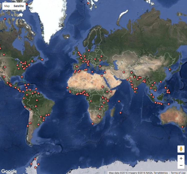
It is a remediated form of the documentary film which Dr. Terry has named a “Geo-Doc”: Geographic Information System maps being used on an overall comparative and documentary level, depicting the director’s vision of actual geographical locations around the world and the social issues affecting the people in these places. GIS maps prove to be an inventive way to zone in on the area of the world which most interests the viewer.

Click on a pin to view this GIS Map of Documentary Films representing each country.

GIS Map of Documentary Films

Along with international feature-length documentaries, you can also view another GIS map of documentary films made in much shorter formats. Students from around the world submitted three-minute film projects to The Youth Climate Report created by Dr. Terry in conjunction with the United Nations Framework on Climate Change. Each year, students are given a choice of two subjects on which to focus, to help inform the world on issues affecting climate change, sustainability, pollution, water, and more. The result is The Youth Climate Report, and the films are juried and published by Dr. Terry and the United Nation Environment Programme to add to this evolving new form of a documentary film project.

Dr. Terry wrote, produced, and directed the documentary films, The Antarctica Challenge – A Global Warning, The Polar Explorer, and The Changing Face of Icelandamong other projects. See a list of his academic accomplishments at Ecotalkers.com, which includes papers and speeches on climate change and how Mark’s reimagining of GIS maps created an evolving form of the interactive documentary. You can read more about how GIS maps are being used for social change and inform policymakers in Dr. Terry’s book The Geo-Doc: Geomedia, Documentary Film, and Social Change released by Palgrave Macmillan in February of 2020.

Data Delivery Systems using GIS Maps

Data Delivery Systems using GIS Maps is an innovative way to inform and educate the world about global climate change.

Geospatial information shared Data Delivery Systems using GIS Maps is a great way to communicate information using statistics, photographs, videos, and more. Take, for example, Mark Terry’s Youth Climate Report published in conjunction with the United Nations Framework on Climate Change via a GIS map. This project focuses on the subjects of climate change, pollution solutions, water management, and inspiration as to the technology and innovations stemming from these areas, as well as the challenges. Every new pin plotted on the map helps develop this new form of interactive spatial and temporal documentary platform. It will continue to grow and be a source for comparative analysis as well as an excellent informational tool for both the world and UN policymakers regarding climate change and managing the earth.

This GIS map project, which was started in 2015, is open to participants from every continent. Submitted videos are juried by members of the UNFCC and Mark Terry to make sure they are of suitable quality and meet one of the two subjects that change each year. If you are interested in participating in next year’s competition, just look at some of the entries to get a feel for what innovative offerings the students are producing for this evolving GIS map.

Data Delivery Systems using GIS Maps

Click on each pin to see a different video.

See the winners of  the COP22 Youth Climate Video Competition, excellent examples of Data Delivery Systems using GIS Maps:

Also, watch the two videos produced by the winners of the 2017 Youth Climate Report Competition.

Watch the video by Faouzia Bahloul:
Watch the video by Phuong Vu Hoang 

Elements to display on interactive GIS maps

Read up on factors and elements to display on interactive GIS maps to share information about residential and commercial properties, neighbourhoods, and cities.

A well-informed potential client makes completing the sales aspect and transaction process easier and quicker. Coming from an advertising background rather than a statistical analysis of factors, Illuminate Geomedia focuses on conveying the content and assets of a property or service, in the most visually pleasing, professional, and descriptive way. A combination of seasoned skills in copywriting, design, photography, and video brings it all together to present properties, services, or events in a succinct and stylish way.

The following categories represent factors and elements that affect decisions made in the real estate market of buyers, sellers, or renters. You can choose to display the factors most relevant to your purposes to populate a custom-made pop-up pin on interactive GIS maps. The possibilities are bountiful when it comes to uploading details to represent and analyze homes, neighbourhoods, communities, economic factors, and much more.

General Factors:

Retail and grocery stores

Health Resources

Schools

Sports Facilities

Parks and Recreation

Community and Youth Services

Entertainment Complexes

Libraries

Banks

Churches

Parking

Aerial Views

Roadways and Commuting Routes

Public Transportation

Waterways

Utilities

Solid Waste Collection and Facilities

Stormwater Management and Infrastructure

Recycling Facilities

Police and Fire Departments

Emergency and Disaster Response

Natural Resources, Flood Zones

Infrastructure

Job Market and Business Resources

Government Services and Departments

Volunteer and Support Groups

Events and Convention Centres

Comparing Values of similar properties within close proximity

Property Assets

Floor Plans

Square Footage of building and property

Number of rooms

Number of bedrooms

Number of bathrooms

Tax assessments

Land Use and Zoning


Other Factors for Analysis and Comparison

Vacancy Rates

Commercial Appraisals

Residential Appraisals

Development and Growth

Insights of market patterns

Investors

Demographics and Diversity

Lifestyles and Statistical Analysis

Spatial Analysis research

Databases

Population

Links to Websites with other pertinent details

Geocoding and Integration

Tourism sites

Elements to display on interactive GIS maps

Geomedia Real Estate Marketing

Geomedia Real Estate Marketing is proving to be an important tool for realtors to share comprehensive details with property buyers and renters. Geographic Information System maps represent a new and exciting format in which to display details about properties for sale or lease, in an industry that is based on ‘location, location, location’! Prospective buyers or renters can simply click on a pin located on a map of the area that they’re interested in Geomedia Marketing Servicesresiding or operating a business, to open up a page chock full of as many details as the marketer wants to upload. This makes the process of locating and comparing specs of properties fast and easy.

Real Estate Agents and Brokers can list every property they represent all over a city. The map can pin properties belonging to their own clients or link to other properties in which that potential clients might be interested, based on the location. It is so easy to discover properties based on location using a GIS map and lead your clients to the neighbourhood in which they are interested in residing.

Geomedia Real Estate MarketingThe map manager can upload detailed contact information for agents and brokers involved with marketing a property or just provide the minimum details in the window plus a link to a full page on a website. Have videos, logos, interior and exterior photos of the property, along with floor plans, aerial and 3D views, embedded directly on the pinned page. Links to a variety of resources can also be uploaded, including an MLS database, tax records, additional videos, and points of interest in the neighbourhood, such as schools, shopping malls, grocery and retail stores, restaurants, transportation routes and hubs, parks, sport, recreation and recycling facilities, and more attributes that people want to know about when they select their new neighbourhood. The buyer or renter can quickly get an idea of property values with a click, allowing them to quickly compare prices, lot size, and other real property data, rather than typing in addresses or combing through MLS listings found in a specific area. Maps can be customized to only have properties listed in a specific price range, lot size, business requirements, or whatever criteria desired.

The beauty of Geomedia Real Estate Marketing is that it is both a visual medium to locate a property as well as a platform to share a wide range of reports and other data for both professionals and prospective home purchasers or renters. Once people get a taste of the ease with which properties can be viewed using the perspective of Geographic Information System maps, there will be no going back!

The types of maps that can be created using GIS technology are limitless. See a sample map that markets Solar Providers. Check out Illuminate Geomedia Marketing Services Facebook page for more on using GIS maps as a marketing tool.